
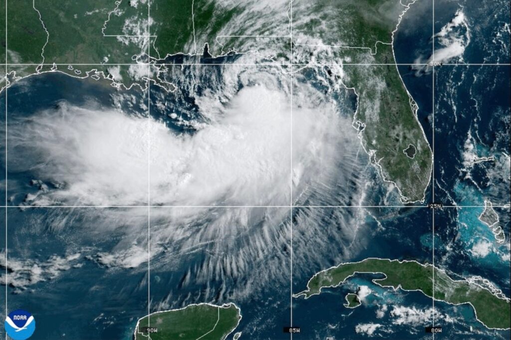
Tropical Storm Bertha made landfall in southern Louisiana on Wednesday, bringing with it strong winds that extended far beyond the storm's center. As the storm approached, beaches were closed from the Florida Panhandle to Mississippi. According to the National Hurricane Center, Bertha hit St. Bernard Parish, approximately 40 miles (65 kilometers) east of New Orleans, in the afternoon. At the time of landfall, the storm boasted maximum sustained winds of about 45 mph (72 kph), with expectations for these winds to persist as it moved towards the upper Texas coast on Thursday.
The primary threats posed by the storm to the Deep South region included wind and storm surge. In response, parks and piers were closed along the coast, and some low-lying roads were also shut down. A tropical storm warning was issued from Alabama to Louisiana, encompassing New Orleans, which was also grappling with extreme heat. By Thursday evening, Bertha's center was situated around 40 miles (70 kilometers) southwest of New Orleans.
As Bertha approached, onlookers gathered at the Lake Pontchartrain estuary, witnessing the storm surge while children played in the floodwaters. Despite rising water levels, some residents were seen mowing their lawns. The National Hurricane Center reported that tropical storm force winds were experienced as far as 160 miles (260 kilometers) from the storm’s center. A wind gust of 44 mph (71 kph) was recorded at New Orleans Lakefront Airport Wednesday afternoon.
The storm also caused minor incidents, such as a Waffle House sign being blown over onto a car in Panama City Beach, Florida. However, the heaviest rains remained offshore, which reduced the risk of significant flooding. Louisiana State Climatologist Jay Grymes assessed that the widespread damage from Bertha was unlikely. He characterized the storm's impact on coastal communities as manageable.
Governor Jeff Landry described the forecast as "encouraging," yet he cautioned residents to prepare for potential flooding. Forecasters indicated that storm surges could reach up to 3 feet (1 meter) in Louisiana and Alabama, with rain totals predicted to be between 1 and 4 inches (3 to 10 centimeters), though isolated areas might see higher amounts.
Bertha is expected to weaken as it moves inland into Texas by Friday, as reported by the hurricane center. In a separate weather event, a line of storms on Tuesday generated tornado reports stretching from Cincinnati to New Jersey, causing flash floods in West Virginia that resulted in home inundations, washed-out bridges, and water rescues.
In a rare weather occurrence, southern Louisiana faced both tropical storm and extreme heat warnings on Wednesday, a combination that has not been seen in the area for over two decades, according to meteorological records dating back to 2005.
Bertha marks the second tropical storm of the current Atlantic hurricane season, following Tropical Storm Arthur in June, which had already caused significant rainfall across the southeastern United States. Bertha's rains are anticipated to impact coastal areas of Mississippi still recovering from the previous flooding caused by Arthur, which resulted in extensive damage to homes.
In the eastern Pacific Ocean, Hurricane Fausto was reported to be churning far from land, positioned hundreds of miles west-southwest of the southern tip of Baja California with maximum sustained winds reaching 80 mph (130 kph). It is expected to gradually strengthen, with ocean swells generated by Fausto causing potentially life-threatening surf and rip currents along the Baja California coast.