
The dynamics surrounding Hurricane Isaias are a complex interplay between a strong El Niño and the warm, storm-fueling waters of the Gulf of Mexico. Colorado State University hurricane researcher Phil Klotzbach described this ongoing struggle between wind shear caused by El Niño and the favorable conditions provided by climate change.
El Niño, a natural phenomenon characterized by the temporary warming of parts of the Pacific Ocean, affects global weather patterns significantly. In this case, its wind patterns have limited the capacity for storms to strengthen in the Atlantic while enhancing storm activity in the Pacific. Klotzbach noted that this year's El Niño has suppressed storm development in the Atlantic, but it hasn't entirely vanquished the conditions necessary for a hurricane to form.
Wind shear, the variation in wind speed and direction with height, plays a crucial role in hurricane formation by disrupting the circular structure of storms, preventing the development of a complete eyewall. However, the Gulf of Mexico offers abundant warm water and moisture that serves as fuel for storm intensification. Currently, the Gulf waters are approximately 2.7 degrees Fahrenheit (1.5 degrees Celsius) warmer than normal, a change attributed to climate change fueled by fossil fuel consumption, according to climate scientist Kristina Dahl.
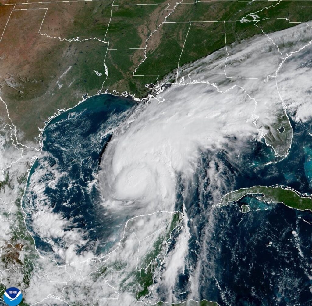
Klotzbach explained that while warm waters and moisture can enhance a storm's strength, extreme wind shear will ultimately determine the storm's fate. Earlier in the week, what began as disorganized thunderstorms over Central America struggled to reach the critical threshold that would allow for storm development, primarily due to El Niño's strong upper-level winds. Fortunately, a temporary decrease in wind shear allowed Isaias to rapidly intensify from 40 mph to 80 mph (64 kph to 129 kph) within just 24 hours. By late Wednesday, Isaias became the latest first Atlantic hurricane of the season since 1914.
By Friday morning, Isaias achieved hurricane status with winds of 120 mph (195 kph), and forecasters anticipated it would make landfall along the coasts of Mississippi, Alabama, or the Florida Panhandle late Friday night or early Saturday. As the storm approached the coast, wind shear was expected to increase significantly, which could hinder further intensification. Klotzbach emphasized that even though wind shear could increase, Isaias would still pose a significant threat upon making landfall.
Despite potential obstacles, the forecast indicates the coastal regions are in a precarious position. A delay of just six hours in the onset of stronger wind shear could result in a much stronger hurricane hitting the shore than expected. The National Hurricane Center warned coastal residents about the potentially life-threatening storm surge, exacerbated by the rising sea levels attributed to climate change. Dahl noted that in some areas, sea levels have risen approximately six and a half inches over the past century due to climate factors.
The warming atmosphere not only promotes the intensification of storms but also increases the amount of rainfall these storms can deliver, thereby enhancing flood risks. The National Hurricane Center also issued warnings about urban, river, and flash flooding in the Southeast over the weekend. Dahl concluded that while both El Niño and climate change play roles in shaping weather patterns, climate change is a significant underlying factor that influences weather on a more extensive scale.