

SAN JUAN, Puerto Rico (AP) – Hurricane Erin weakened to a Category 3 hurricane on Sunday, but its extensive outer bands continued to batter the Virgin Islands and Puerto Rico. Forecasters warned of increasing risks of life-threatening surf and rip currents along the U.S. Eastern seaboard as Erin is expected to evolve into a very large hurricane throughout the week.
Although Erin's maximum winds decreased, its overall size expanded, prompting the issuance of tropical storm warnings for the Turks and Caicos Islands as well as the southeast Bahamas. The hurricane's outer bands unleashed heavy rains and tropical-storm winds across parts of Puerto Rico and the Virgin Islands during the day.
While the storm is not expected to make direct landfall on the U.S. East Coast, its growth poses a threat to the North Carolina Outer Banks, a series of thin barrier islands that extend into the Atlantic. Dare County emergency officials declared a state of emergency and ordered an evacuation of Hatteras Island to begin Monday. They cautioned that several days of heavy surf, high winds, and large waves could damage portions of North Carolina Highway 12, a popular route for vacationers.
The center of Erin is projected to remain at least 200 miles (320 kilometers) away from the Outer Banks, but the storm's rip currents are expected to impact all areas along the East Coast. Officials indicated that Bermuda may experience similar conditions as Erin shifts to the north and then northeast.
Erin, the first Atlantic hurricane of the 2025 season, reached a dangerous Category 5 status on Saturday with maximum winds of 160 mph (260 kph) before weakening to 125 mph (205 kph) by Sunday afternoon, according to the National Hurricane Center in Miami. The decrease in wind speed was a result of internal changes within the storm, but forecasters predict Erin will maintain its power for several days and may strengthen again in the next 48 hours.
Richard Pasch of the National Hurricane Center emphasized the seriousness of the storm, stating, "You’re dealing with a major hurricane. The intensity is fluctuating. It’s a dangerous hurricane in any event."
As of Sunday afternoon, Erin’s center was located approximately 310 miles (500 kilometers) northwest of San Juan, Puerto Rico, and 155 miles (245 kilometers) east-northeast of Grand Turk Island, moving west-northwest at a speed of 13 mph (20 kph). Forecasts suggest the core of Erin will pass east and northeast of the Turks and Caicos and southeastern Bahamas overnight into Monday.
The outer bands of the storm caused power outages for around 147,000 customers in Puerto Rico by Sunday morning, according to Luma Energy, the private company responsible for power transmission and distribution on the island. The severe weather led to the cancellation of more than 20 flights.
Forecasters also warned of surf swells affecting the Virgin Islands, Puerto Rico, Hispaniola, and the Turks and Caicos Islands over the next few days. The Coast Guard allowed all ports in Puerto Rico and the U.S. Virgin Islands to reopen on Sunday as winds and rain diminished in the area.
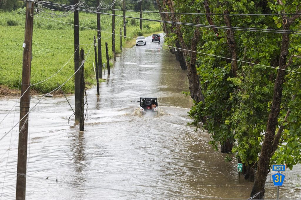
A tropical storm warning indicates that tropical storm conditions are expected in the warning area within 24 hours. The hurricane center also predicted heavy rains across the Virgin Islands and Puerto Rico, with expected rainfall amounts of 3 to 6 inches (7.6 to 15 centimeters), and isolated areas might see up to 8 inches (20 centimeters).
Scientists have linked the rapid intensification of hurricanes in the Atlantic to climate change, noting that global warming contributes to an increase in atmospheric water vapor and higher ocean temperatures. Warmer waters provide more fuel for hurricanes, enabling them to unleash greater amounts of rain and intensify more quickly.